 HuntGrid
 Backcountry (beta)
Free trip planner for canoe, portage and hiking trips
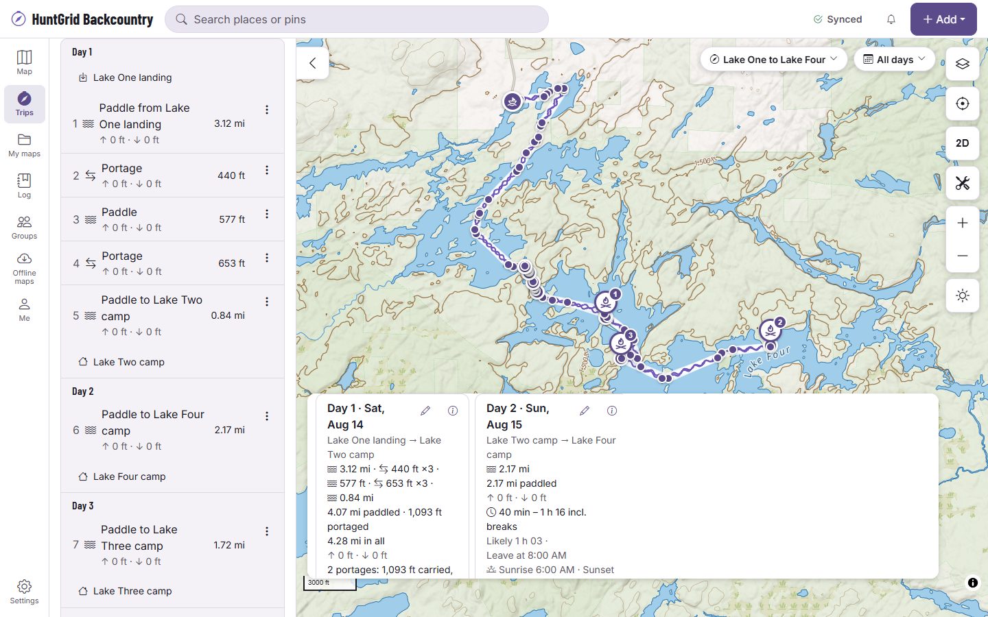
Plan canoe, portage and hiking trips day by day, with an honest time range for every leg and the source of every fact. Estimates for planning, not promises. Official park maps, rules and signs control.
Map data © OpenStreetMap contributors, © OpenMapTiles; terrain: Copernicus WorldDEM-30 (credits)
Built for trippers, from one night to three weeks
HuntGrid Backcountry is in open beta for parks, forests and wilderness in the US and Canada. What’s here works today; more is on the way.
A planner with honest time ranges
Draw a trip from paddle, portage and hike legs. Each leg gets a time range from its distance, climb, carries, current and the forecast wind, with the assumptions it used, and you can change them.
Days, camps and bail-outs
Split the trip into days with a camp each night, a plan B camp and spare days for wind or weather. Each day shows its hours on the move, its daylight and the ways out from each camp.
Conditions along the route
Forecast wind and waves on each lake leg, river gauges, warnings, fire and smoke on the days of your trip, each with its source and time. Set your own wind limit and see which start times keep every open-water leg under it.
A trip plan and check-in
Leave a trip plan with a contact you trust: your route, your party and when you expect to be back. Check in to move the time, and your contact gets an email if you’re overdue. It isn’t a rescue service: carry a satellite messenger or beacon.
Gear, food and carried weight
Your gear closet, a list for each trip, meals by day and who carries what. The weight on each back is shown morning by morning, falling as the food is eaten and rising at a resupply.
Trip packs and Trip Mode, offline
Download a trip before you go: the map along every day, the cards, the last conditions and the itinerary keep working with no signal. On the water, Trip Mode shows the day, the distance and time left to camp, the daylight left and the nearest exit, with big buttons.
Routing on trails and portages
Ask for a route that follows trails, portages and lake crossings between your stops, then compare it with the alternatives.
Plan with your party
Invite your party to the trip, give each person a role, share paces so the plan can use the slowest one, and chat on the trip.
Fishing on the trip
Each lake on your route with its species and HuntGrid Fishing’s summary of the rules on your dates, your licence checked against them, and catches logged in Trip Mode with no signal.
Field reports that expire
Trippers report blowdowns, beaver dams and flooded portages, even with no signal. Each report shows its date on the card and the day, and fades away when it’s old.
Your log, recap and export
Keep what you actually did, notes and photos by day, and a recap of the trip. Export the plan or the track as GPX or KML, or print the itinerary.
One account with every HuntGrid app
The same free account as HuntGrid’s hunting, fishing and offroad apps, on every device.
Each day
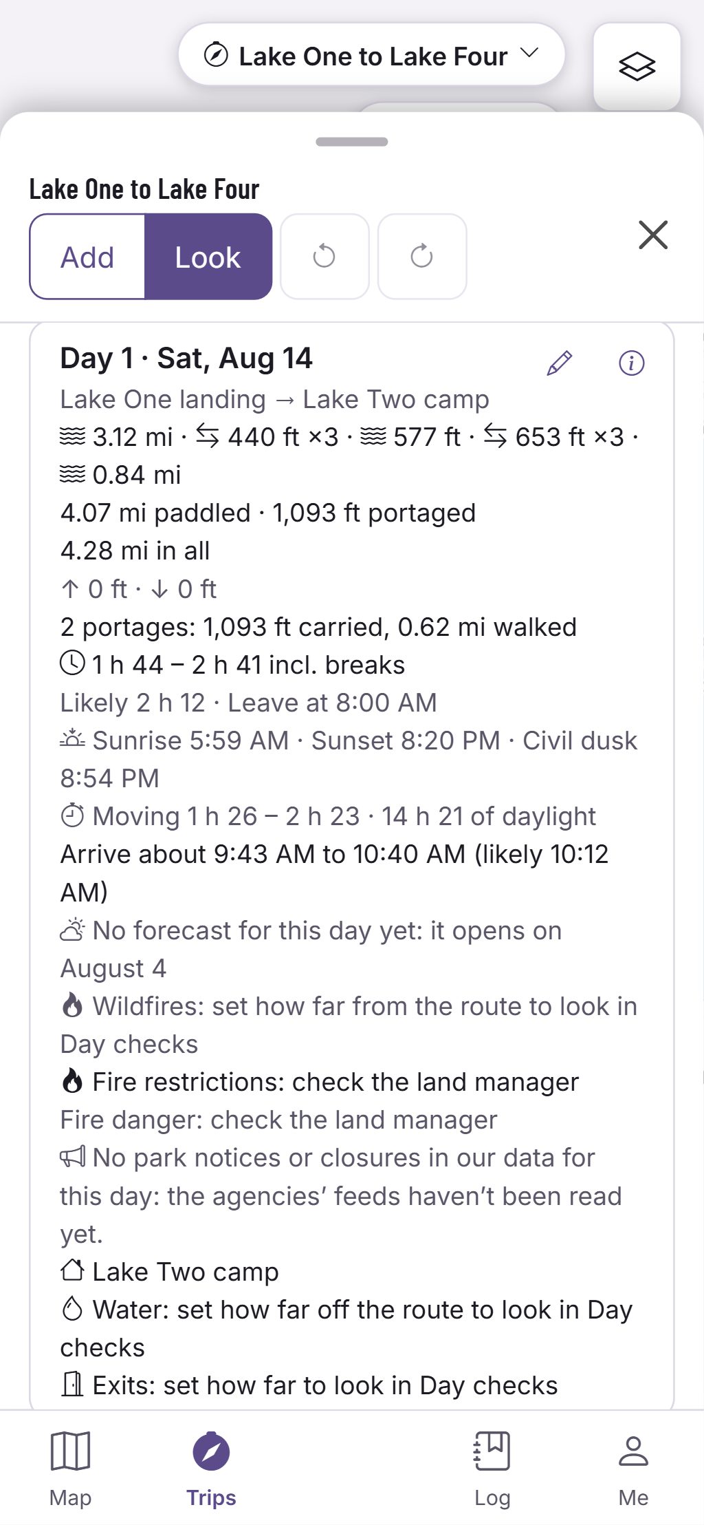
Times with their reasons, never a promise
Open a day to see its legs, its camp and how the time was worked out.
- A range for each leg, with the pace, carries, current and wind it assumed.
- Sunrise, sunset and the daylight left after the last leg.
- Every portage, trail and campsite names its source and date; unverified ones say so.
Estimates for planning, not promises. Official park maps, rules and signs control.
Park pages: canoe routes, portages and campsites
Each park has its own page on backcountry.huntgrid.net: trails, portages and campsites from official data and OpenStreetMap, side by side, with their date and a link to the official park page. A few of the most searched:
Canoe camping in Quebec
Sépaq and Parks Canada portages and trails, park pages, portage times, wind on big lakes and a trip plan.
Algonquin Provincial Park
Ontario
Quetico Provincial Park
Ontario
Superior National Forest and the Boundary Waters
Minnesota
Killarney Provincial Park
Ontario
La Mauricie National Park
Quebec
Kejimkujik National Park
Nova Scotia
Map data © OpenStreetMap contributors, © OpenMapTiles; terrain: Copernicus WorldDEM-30 (credits); lidar: USGS 3D Elevation Program; Natural Resources Canada HRDEM, contains information licensed under the Open Government Licence – Canada; via Mapterhorn
Lidar terrain
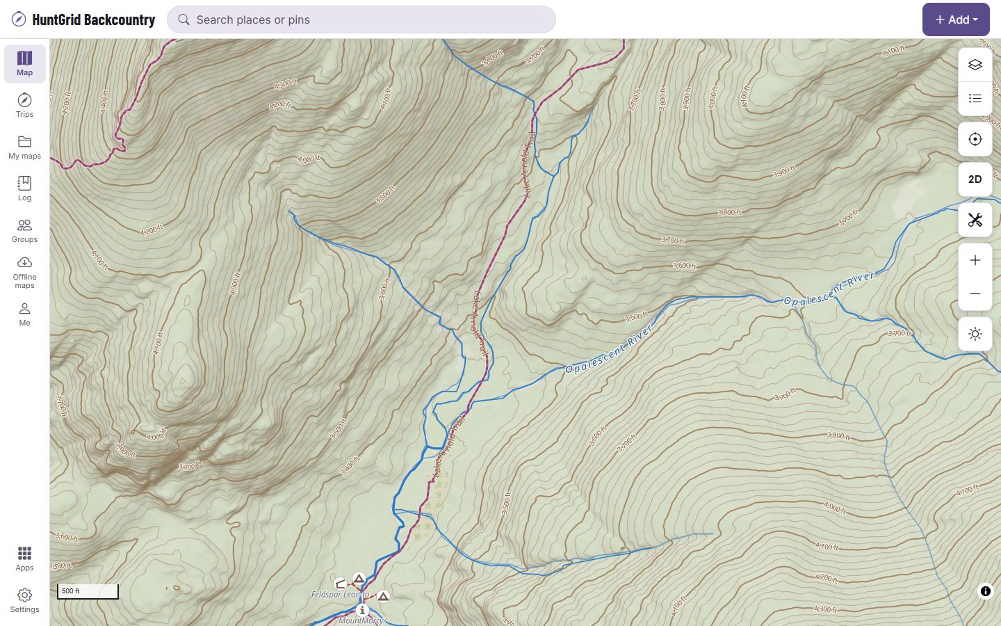
Lidar terrain for reading the ground
Zoom in close in the United States or Canada and the hillshade and contour lines are drawn from lidar, wherever it has been flown: benches, flat ground and gullies along a river or a portage.
- The elevation profile of each leg reads the lidar too.
- From the USGS 3D Elevation Program in the United States (lidar where it has been flown, its 10 m model elsewhere) and Natural Resources Canada’s HRDEM where it has been flown. Where there is none (much of the far north, for one), the map keeps its standard 30 m terrain.
- Download an area for offline use and the lidar detail comes with it (a very large area keeps the standard terrain).
Flat ground in the shading is not a campsite. Where you may camp is what the park’s official maps and rules say.
Map data © OpenStreetMap contributors, © OpenMapTiles; terrain: Copernicus WorldDEM-30 (credits)
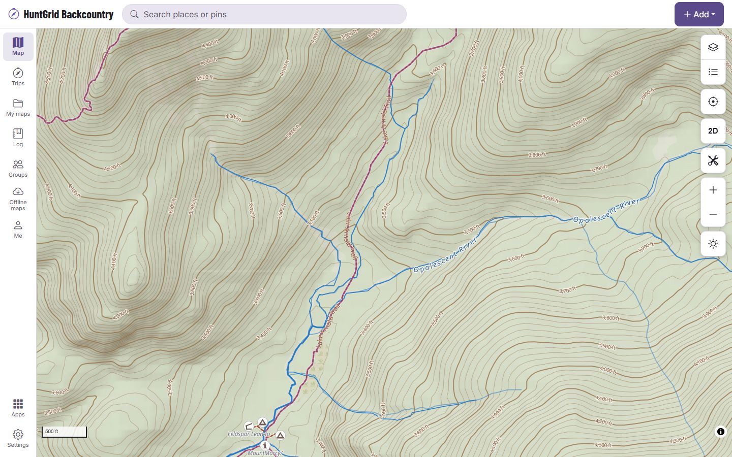
The same ground without lidar
This is the same view on the standard 30 m terrain, which is what the map shows where no lidar has been flown. Zoomed out, the two look alike; the detail shows when you zoom in close.
All 62 map layers in HuntGrid Backcountry
Portages, trails, campsites, land, water, weather and fire: every layer you can turn on in HuntGrid Backcountry today.
Base maps (4)
Topo · Satellite · Hybrid · Dark
Aerial and satellite imagery (5)
Sentinel-2 imagery · Yukon imagery · Québec imagery · Ontario imagery · New Brunswick imagery
Terrain (6)
Terrain (elevation) · Lidar terrain detail · Relief detail · Terrain shapes · Canopy height (modelled) · Openings & edges (modelled)
Public land and boundaries (7)
Public land (US) · Mining claims (BLM MLRS) · PLSS grid (townships and sections) · Public land (Canada) · Protected areas (worldwide) · Data coverage: portages · Data coverage: campsites
Roads, trails and access (7)
Trails, tracks and gates · Portages, canoe routes & rapids (OpenStreetMap) · Official trails & portages · Climbing closures · Fishing access · Fishing access (share-alike agency data) · Fishing access from OpenStreetMap
Places, camps and names (6)
Crags, routes & boulders (OpenStreetMap) · Campsites, water & trailheads (OpenStreetMap) · Campgrounds (official) · Registered tourist campgrounds (Quebec) · Backcountry campsites, water & access (official) · Collecting sites
Rivers and lakes (2)
Rivers and streams · Lakes and rivers
Nautical (1)
Seamarks, marinas and anchorages (OpenStreetMap)
Hazards on the water (3)
River hazards · Weirs and dams from OpenStreetMap · Old mine workings
Weather and forecasts (12)
Weather stations · City forecasts · Wind flow (forecast) · Radar · Wind arrows (forecast) · Wind speed (forecast) · Gusts (forecast) · Temperature (forecast) · Cloud cover (forecast) · Lightning · Thunderstorm outlooks and watches · Weather alerts
Fire and smoke (5)
Wildfire smoke (forecast) · Smoke (satellite analysis) · Wildfires · Fire hotspots (24 h) · Fire danger (Canada)
Snow and water levels (4)
Reports from trippers · Snow depth · Water levels · Webcams
The names as the app’s layer panel shows them. Some layers cover only the places their source maps; each says where in the app.
One free account for every HuntGrid app
Already use HuntGrid Hunt, HuntGrid Fishing, HuntGrid Offroad, HuntGrid Climbing or HuntGrid Sailing? Sign in to HuntGrid Backcountry with the same account, on every device.
Questions
Still have a question? Read the HuntGrid Backcountry help pages or email support@huntgrid.net.
Is HuntGrid Backcountry really free?
Yes. Everything on this page is in the free plan, with no credit card. HuntGrid Backcountry is in open beta: anyone can use it while we keep building. There are no ads.
Can I browse parks, trails and campsites by state or province?
Yes. Every state and province has its own page of parks, trails, canoe routes, campsites and trailheads from official park data: United States · Canada.
Does it work with no cell signal?
Yes, once you download the trip. Its pack holds the map along every day, the leg and day cards, the last conditions with their age, and the itinerary, and what you add on the trip syncs when you’re back in range. Expect no cell signal out there: carry a satellite messenger or beacon.
Where does the data come from, and what does “unverified” mean?
Portages, trails, campsites and access points come from official park and forest data where it’s open, and from OpenStreetMap, which is kept apart and labelled. Every feature names its source and date. Unverified means no official source confirms it yet: check the park’s own maps. Official park maps, rules and signs control.
Is a time a promise?
No: a planning range with its assumptions. Each leg’s range comes from published travel-time models and your own pace settings, and the card shows which. Wind, water levels, loads and the party change the real time.
Does check-in replace a satellite messenger?
No: it’s a backup. Your contact gets an email if you’re overdue. It isn’t a rescue service: carry a satellite messenger or beacon.
Can I use my HuntGrid account?
Yes. HuntGrid Hunt, HuntGrid Fishing, HuntGrid Offroad, HuntGrid Climbing or HuntGrid Sailing and HuntGrid Backcountry share one free account: sign in to backcountry.huntgrid.net with the same email and password or passkey, on every device.
Does it work on iPhone and Android?
Yes, and on tablets and computers. It’s a web app: open backcountry.huntgrid.net, then on iPhone choose Share and Add to Home Screen in Safari, or on Android choose Install app in Chrome. It isn’t in the App Store or Google Play yet.
Is HuntGrid Backcountry available in French?
Yes. The whole app is available in English and Canadian French, as HuntGrid Arrière-pays. Voir la page en français.
Your next trip starts on the map
Create a free account and open HuntGrid Backcountry in your browser. The same account works for every HuntGrid app.
Already have an account? Sign in