 HuntGrid
Guide · 9 min read
How to find public hunting land
Millions of acres of public land are open to hunters across the US and Canada, but "public" never means "anything goes". Here is where to look, what each kind of land usually allows, and how to confirm the rules before you walk in.
Map data © OpenStreetMap contributors, © OpenMapTiles; terrain: Copernicus WorldDEM-30 (credits)
On this page
Finding a place to hunt is the first hurdle for most hunters, and public land is the answer for a lot of us. It often costs nothing beyond your licence, it can be huge, and some of it holds excellent game. The catch: every type of public land has its own owner, its own rules and its own exceptions. A map tells you who owns the ground. Only the regulations tell you what you may do there.
The main kinds of public hunting land in the United States
National forests and grasslands
National forests are open to hunting in most places under your state's hunting regulations and licence. Expect exceptions: developed campgrounds, trailheads, some recreation areas and areas near buildings are often closed to shooting, and individual forests can issue closure orders. Many national forests are a patchwork with private land inside their outer boundary, so the line on a road atlas is not the line that matters.
BLM land
Bureau of Land Management land, mostly in the West, is generally open to hunting under state rules. The challenge is access. Many BLM parcels are surrounded by private land, and you need a legal way in: a public road, an adjacent public parcel, or the landowner's permission. Corner crossing (stepping diagonally between two public sections that only touch at a corner) is a legal grey area that depends on where you are. HuntGrid can show corner points and the corner-crossing rules it knows of, but read the current law for your state before you try it.
State wildlife management areas and game lands
Each state runs its own system, under names like wildlife management areas (WMAs), state game lands, state wildlife areas or public hunting areas. They were often bought with hunters' licence money and are managed for wildlife, but they tend to have the most specific rules: shorter seasons, sign-in sheets, permits or draws, limits on hunting days, or bans on certain methods. Always read the area's own page, not just the statewide regulations.
National wildlife refuges
Only some national wildlife refuges allow hunting, and those that do usually allow it only on parts of the refuge, for certain species, with refuge-specific rules that can be stricter than the state's. Some require a refuge permit. Treat a refuge as closed until the refuge's own hunting regulations say otherwise.
State trust land
Many western states hold trust land to raise money for schools. The rules vary a lot from state to state: some open it to hunting with a regular licence, some require a separate permit or access fee, and some keep it closed unless leased. Check the state land office as well as the wildlife agency.
Walk-in and access programs on private land
Several states pay or partner with landowners to open private land to public hunting, through programs with names like walk-in areas, block management or Access Yes!. These areas are marked with signs, often have their own rules (foot traffic only, sign-in, certain species, certain dates), and the list changes every year as landowners join or leave.
Public land in Canada
Crown land
Most of Canada's land is Crown land, owned by the provinces and territories. Residents can generally hunt on it under provincial or territorial rules, and non-residents often need a guide or an outfitter for big game. But Crown land is not a free-for-all. Provincial parks, ecological reserves, conservation reserves, wildlife sanctuaries and many protected areas are closed or restricted, and Crown land can be leased or under a land-use permit that limits access.
First Nations reserve land
Reserve land is not public land. You need the permission of the First Nation, and treaty and land claim areas can have their own arrangements. Respect them as you would any private owner.
Quebec's ZECs, wildlife reserves and outfitters
Quebec organises much of its public hunting territory differently. ZECs (zones d'exploitation contrôlée) are public territories run by non-profit organisations: anyone can hunt there, but you must register and usually pay a daily or seasonal fee. Wildlife reserves (réserves fauniques) are managed by the province's park agency, and big-game hunting there is often by draw or reservation. Outfitters (pourvoiries) offer lodging and services, and some hold exclusive hunting rights over their territory, so you cannot hunt there without going through them.
How to find public hunting land, step by step
Start with the wildlife agency
Your state or provincial wildlife agency lists its own areas and access programs, and its regulations name the land types where hunting is allowed or banned. That is your rulebook.
Put it on one map
Land maps from different agencies are hard to compare. In HuntGrid, public land, access programs and closed areas sit on one map with the hunting units, so you can see which unit a parcel is in.
Tap to read the rule
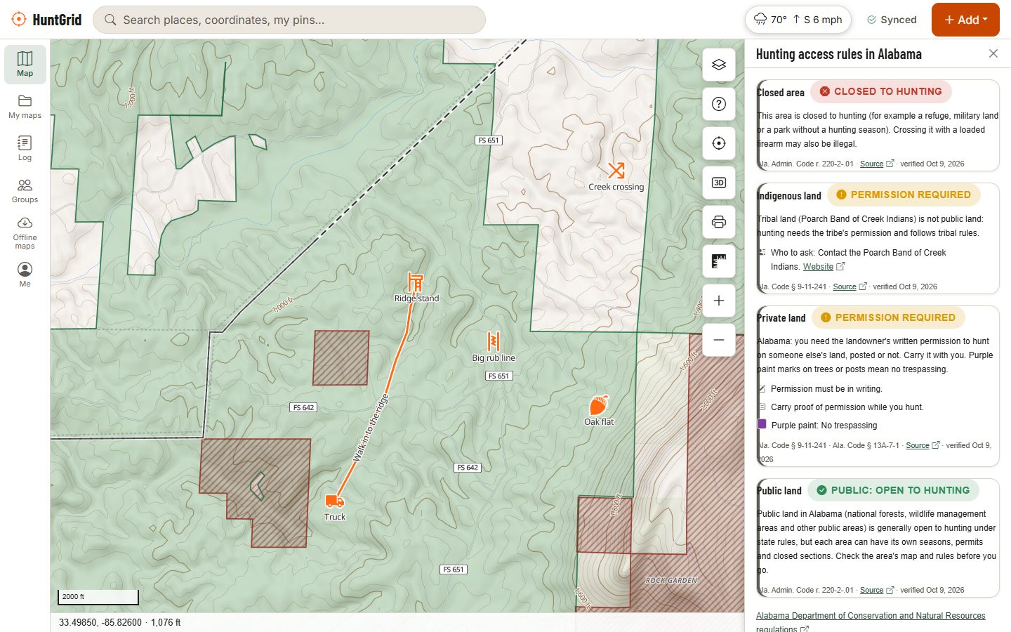
Tap a spot and "Can I hunt here?" says what kind of land it is (public, access program, permission needed or closed) and the rule in plain words, with its official source and date. Access rules are still being checked one jurisdiction at a time, and the app says when a rule isn't verified yet, with a link to the regulations.
Check how you get in
Look for a legal route: a public road, a trailhead, a boat launch, an adjoining public parcel. HuntGrid shows roads and trails open to vehicles and gates other hunters have reported, but a closed gate on the day beats any map.
Confirm, then scout
Call or email the land manager when anything is unclear, then download the area for offline use and go look at it before the season.
Mistakes that get public-land hunters in trouble
- Trusting an old map. Boundaries, closures and access programs change. Use current data and look at the date of the source.
- Assuming land is open because it is green. A colour on a map is a land type, not a permission. Many public lands have closed sections, and safety zones around homes and buildings apply everywhere.
- Hugging the line. Phone GPS can be off by several metres, more under heavy canopy. Stay well inside the boundary and respect posted signs.
- Crossing private land to get in. Trespass laws differ a lot between states and provinces, and so do the rules about posting. When in doubt, ask the landowner. In many US states HuntGrid shows parcel lines and the owner's name on rural land, so you know who to ask.
- Forgetting the season rules. Being allowed on the land doesn't mean the season is open, and some areas have their own dates.
Finding the good spots once you know the land is open
The easiest public land to reach gets the most pressure. Look at the map for ground that takes effort: the far side of a creek, the top of a steep climb, a pocket a mile from the nearest road, or a small parcel everyone drives past. Our guide to e-scouting public land shows how to read terrain for the spots worth walking to.
And when you get there, HuntGrid warns you near homes and buildings and alerts you when you walk up to closed land, from the offline map on your phone. It's a help, not a guarantee: the regulations and the signs on the ground always have the final word.
Questions
Still have a question? Read the help pages or email support@huntgrid.net.
Can I hunt on any public land?
No. Many kinds of public land allow hunting, but national parks, many refuges, some state lands, provincial parks and ecological reserves are closed or restricted, and safety zones around buildings apply everywhere. Check the land manager's rules and your hunting regulations.
Is BLM land open to hunting?
Generally yes, under your state's hunting regulations, but you need legal access. Many BLM parcels are surrounded by private land, and corner crossing is legally unsettled in places.
Can I hunt on Crown land in Canada?
Residents can generally hunt Crown land under provincial or territorial rules, but parks, ecological reserves, sanctuaries and some leased lands are closed or restricted, and non-residents often need a guide for big game. Check your province's regulations.
How do I know if I'm on public land without cell service?
Download the area before you go. HuntGrid shows land status, your GPS position and closed-land alerts offline. How to hunt without cell service.
Are walk-in hunting areas free?
Usually yes for licensed hunters, but each program has its own rules, signs, dates and sometimes a sign-in or permit. The list of enrolled land changes every year, so check the current year's atlas.
Your next hunt starts on the map
Create a free account, download your area and head out. No credit card, no per-state fees.
Already have an account? Sign in