 HuntGrid
 Climbing
Free climbing app for crags, boulders and gyms
Find crags and gyms, check the rain and closures before you go, and log your sends. Every condition and closure shows its source and time, and the app never tells you the rock is fine: you judge it.
Map data © OpenStreetMap contributors, © OpenMapTiles; terrain: Copernicus WorldDEM-30 (credits)
Built for climbers, outdoors and in the gym
HuntGrid Climbing is in open beta and coverage is growing. What’s here works today; more is on the way.
Crags and gyms on one map
Outdoor crags, boulders and indoor gyms in the US and Canada, with routes by wall, grade, type and length. Grades show in the system you pick, marked ≈ when converted. Browse every crag by state and province.
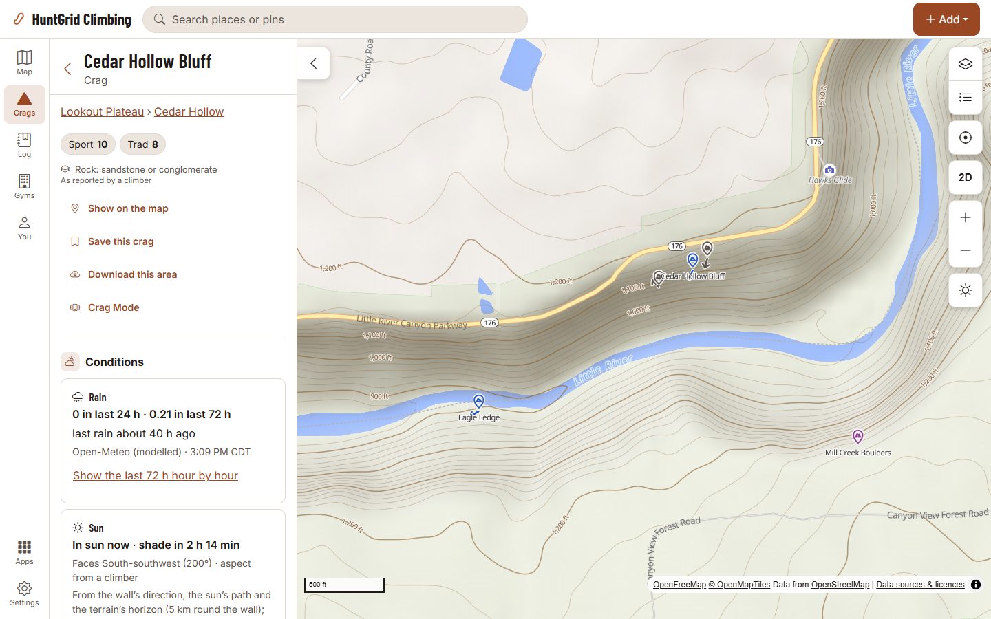
Rain at the crag, with its source
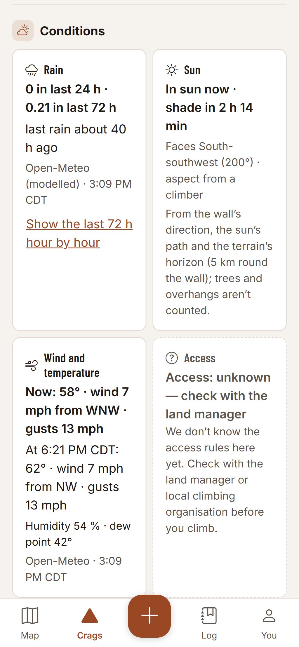
How much rain fell in the last 24 and 72 hours and how long since the last rain, each with its source and time. Facts, never a verdict: you judge the rock.
Sun or shade on the wall
Which way each wall faces and the hours it gets sun, from the terrain. Trees and overhangs aren’t in the model, and the sheet says so.
Closures from the land manager
Closures show as published, with the agency or organisation, its dates and a link to the notice. Where we don’t know the access rules, the crag says “unknown”, never a green tick.
Parking and the walk in
Where to park, the approach on the map with its climb, and a walking time range for it.
Your log, private by default
Tick a route in two taps, indoors or out, with the style, partners and a note. Each tick stays private unless you share it with your group or everyone.
Sends your partner can confirm
Ask your partner to confirm a send. The badge says exactly what happened, like “Confirmed by Sam”, and nothing more: not the grade, not the style.
Gyms and a free setter tool
Find gyms near you and see their problems by colour and grade. Gym staff post sets and resets, print QR tags and verify sends at the desk, with no vendor contract.
Free offline crag packs and Crag Mode
Download a crag before you go: the map, routes, topos and the last conditions keep working with no signal. At the base of the wall, Crag Mode puts big buttons on one screen.
Crag alerts
A heads-up when a closure is in force at a crag you saved, and the rain facts there with their source. In the app, by push or by email.
Add and fix routes
Missing a route or a topo? Add it. Every new route shows “Unconfirmed” until a second climber or a moderator confirms it.
Gym comps
Gyms run simple comps with judge mode and a live leaderboard. Leaderboards are opt-in and count only ticks their owners made public.
Plan a crag day
Pick the routes for the day and share the list with your group or a link.
Today at your crags
Your saved crags and the nearest ones, each with the last rain reported and its source, the longest without rain reported first and crags closed today last.
Map data © OpenStreetMap contributors, © OpenMapTiles; terrain: Copernicus WorldDEM-30 (credits)
The crag sheet
Facts with their source, never a verdict
Tap a crag to see what is known about it today, and where each fact comes from.
- Rain in the last 24 and 72 hours, with its source and the time it was read.
- Closures as the agency or organisation published them, with their dates and a link.
- Access the app doesn’t know about says “unknown”. Check with the land manager or the local climbing organisation.
Climbing can kill. Route information comes from other climbers and public sources and can be wrong. Check the rock, gear and anchors yourself.
Alerts
News from the crags you saved
Save your crags, turn on the alerts you want, and HuntGrid Climbing tells you when something changes there. Each alert is a card: tap it for what we saw, why it matters and a link to the crag. All alerts are free, and each one stays off until you turn it on.
Closures at saved crags
When a land manager’s closure we’ve checked is in force at a crag you saved, once a season, with who issued it and its dates. A voluntary closure says climbers are asked to stay off, as its issuer puts it. A summary: read the official notice before you go.
Rain at saved crags
Rain reported in the last 24 hours at a crag you saved, and when no rain has been reported there for 48 hours after a rain. The source’s own figures, with the source named: radar, a station and its distance, or a model.
Partners and confirmations
No switch needed: when a climber asks to climb with you through the partner finder, or asks you to confirm a send you did together, it shows in your notifications. A confirm request also comes as a push.
Alerts come in the app, as a push on your phone or in a daily email, with the same account and settings as every HuntGrid app. Facts from their sources, not advice: check the rock and the access yourself.
Map data © OpenStreetMap contributors, © OpenMapTiles; terrain: Copernicus WorldDEM-30 (credits); lidar: USGS 3D Elevation Program; Natural Resources Canada HRDEM, contains information licensed under the Open Government Licence – Canada; via Mapterhorn
Lidar terrain
Lidar terrain for cliffs and approaches
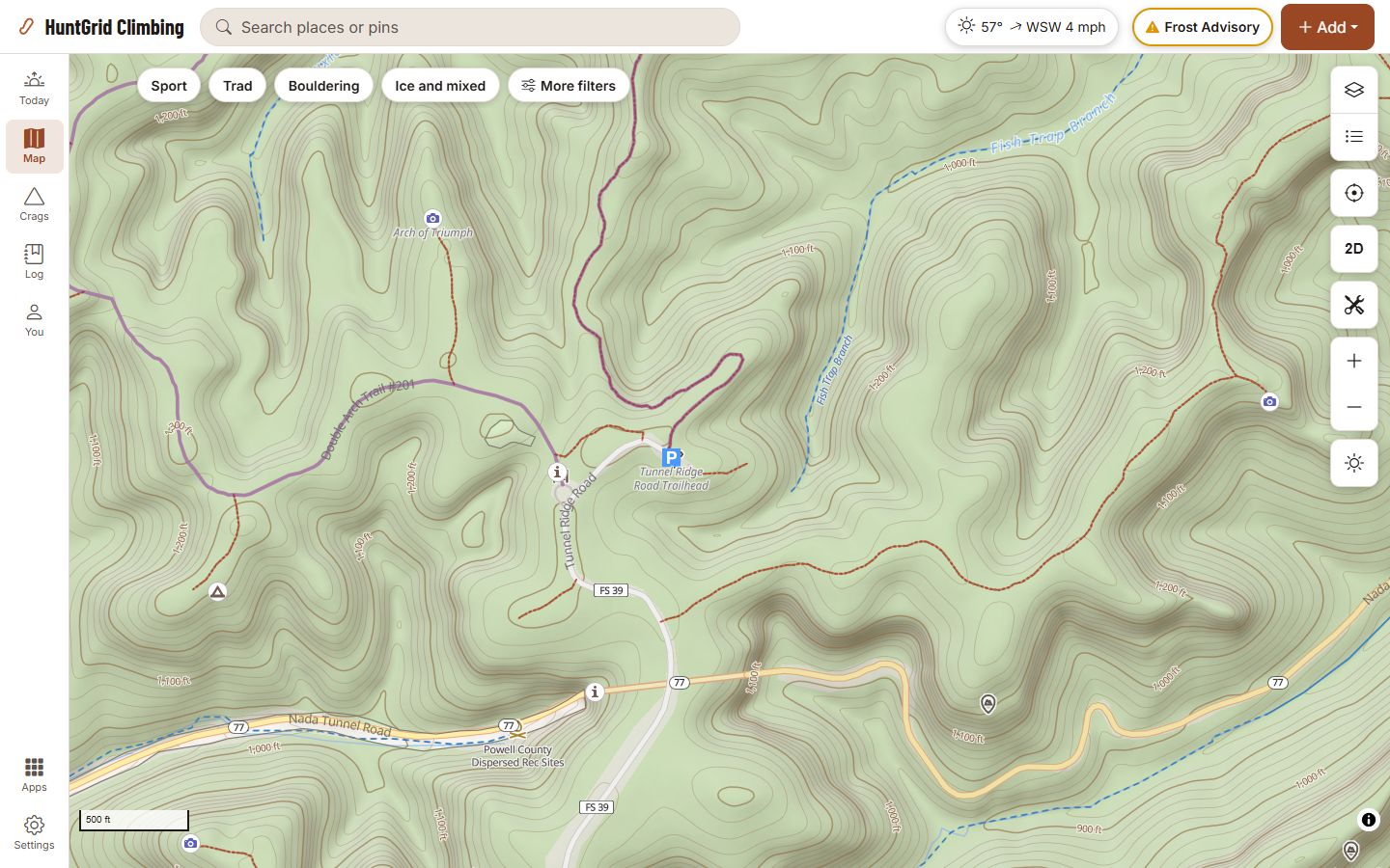
Zoom in close in the United States or Canada and the hillshade and contour lines are drawn from lidar, wherever it has been flown: the cliff bands along a ridge, the gullies below them, and how steep the approach is.
- The elevation readouts read the lidar too.
- From the USGS 3D Elevation Program in the United States (lidar where it has been flown, its 10 m model elsewhere) and Natural Resources Canada’s HRDEM where it has been flown. Where there is none (much of the far north, for one), the map keeps its standard 30 m terrain.
- Download an area for offline use and the lidar detail comes with it (a very large area keeps the standard terrain).
The map shows the shape of the ground, not the rock or the access: check them yourself, with the land manager or the local climbing organisation.
Map data © OpenStreetMap contributors, © OpenMapTiles; terrain: Copernicus WorldDEM-30 (credits)
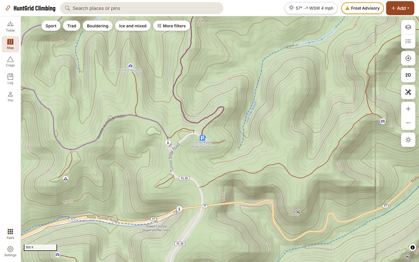
The same ground without lidar
This is the same view on the standard 30 m terrain, which is what the map shows where no lidar has been flown. Zoomed out, the two look alike; the detail shows when you zoom in close.
All 49 map layers in HuntGrid Climbing
Crags, closures, land, trails and weather: every layer you can turn on in HuntGrid Climbing today.
Base maps (4)
Topo · Satellite · Hybrid · Dark
Aerial and satellite imagery (5)
Sentinel-2 imagery · Yukon imagery · Québec imagery · Ontario imagery · New Brunswick imagery
Terrain (6)
Terrain (elevation) · Lidar terrain detail · Relief detail · Terrain shapes · Canopy height (modelled) · Openings & edges (modelled)
Public land and boundaries (3)
Public land (US) · Public land (Canada) · Protected areas (worldwide)
Roads, trails and access (4)
Trails, tracks and gates · Portages, canoe routes & rapids (OpenStreetMap) · Official trails & portages · Climbing closures
Places, camps and names (4)
Climbing gyms · Crags, routes & boulders (OpenStreetMap) · Campgrounds (official) · Backcountry campsites, water & access (official)
Rivers and lakes (1)
Rivers and streams
Hazards on the water (2)
Mapped landslides (USGS) · Old mine workings
Weather and forecasts (12)
Weather stations · City forecasts · Wind flow (forecast) · Radar · Wind arrows (forecast) · Wind speed (forecast) · Gusts (forecast) · Temperature (forecast) · Cloud cover (forecast) · Lightning · Thunderstorm outlooks and watches · Weather alerts
Fire and smoke (5)
Wildfire smoke (forecast) · Smoke (satellite analysis) · Wildfires · Fire hotspots (24 h) · Fire danger (Canada)
Snow and water levels (3)
Snow depth · Water levels · Webcams
The names as the app’s layer panel shows them. Some layers cover only the places their source maps; each says where in the app.
One free account for every HuntGrid app
Already use HuntGrid Hunt, HuntGrid Fishing, HuntGrid Offroad or HuntGrid Backcountry? Sign in to HuntGrid Climbing with the same account, on every device.
Questions
Still have a question? Read the HuntGrid Climbing help pages or email support@huntgrid.net.
Is HuntGrid Climbing really free?
Yes. Everything on this page is in the free plan, with no credit card, offline crag packs included. HuntGrid Climbing is in open beta: anyone can use it while we keep building. There are no ads.
Can I browse crags and gyms by state or province?
Yes. Every state and province has its own page of crags, routes and climbing gyms: Where to climb.
Will it tell me if the rock is dry?
No. It gives you the facts with their source and time: rain in the last 24 and 72 hours and how long since it last rained. Rock dries differently by type, aspect and wind, so you judge it at the crag. Where a land manager publishes a rule about wet rock, the crag quotes it and links to it. Climbing after rain: the facts and the cited cautions.
Where does the route data come from?
From OpenStreetMap and from climbers who add routes in the app, never from other climbing apps or guidebooks. Coverage is growing and thinner in some areas. Every route someone adds shows “Unconfirmed” until a second climber or a moderator confirms it. Route information can be wrong: check the rock, gear and anchors yourself.
Who can see my ticks?
Only you, unless you share a tick with your group or make it public. The optional location check keeps only whether your phone was at the crag, never where you were. A gym sees only totals and the ticks climbers made public.
Can I use my HuntGrid account?
Yes. Every HuntGrid app shares one free account: sign in to climbing.huntgrid.net with the same email and password or passkey, on every device.
Does it work on iPhone and Android?
Yes, and on computers. It’s a web app: open climbing.huntgrid.net, then on iPhone choose Share and Add to Home Screen in Safari, or on Android choose Install app in Chrome. It isn’t in the App Store or Google Play yet.
Is HuntGrid Climbing available in French?
Yes. The whole app is available in English and Canadian French, as HuntGrid Escalade. Voir la page en français.
Your next crag day starts on the map
Create a free account and open HuntGrid Climbing in your browser. The same account works for every HuntGrid app.
Already have an account? Sign in