 HuntGrid
 Sailing
Free sailing app for planning passages and cruises
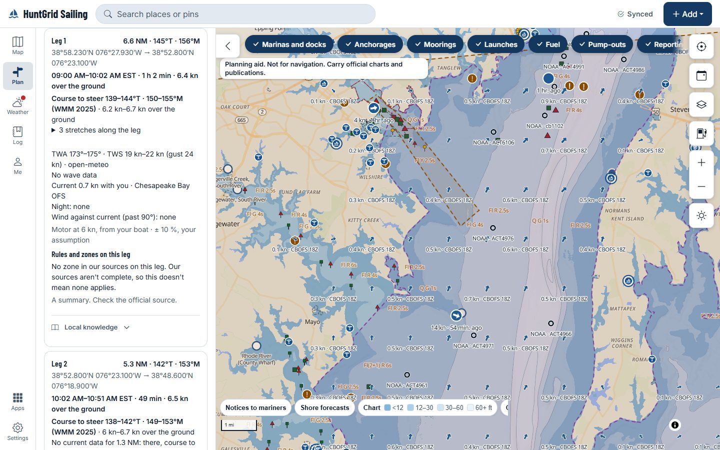
Plan a cruise in legs and see the tide, current, wind and waves each leg meets at your times, the rules where you anchor and the warnings on your route. Every fact shows its source and time. A planning aid, not for navigation.
Map data © OpenStreetMap contributors, © OpenMapTiles; terrain: Copernicus WorldDEM-30 (credits)
Built for sailors, from day sails to long cruises
HuntGrid Sailing is in open beta for US and Canadian waters. What’s here works today; more is on the way.
A passage in legs on one map
Plan a cruise as passages and legs, with an arrival time for each stop and the tide, current, wind and waves each leg meets at your times, each with its source and model.
Depth and air draft at your arrival time
Charted depth below its chart datum, the predicted tide at your arrival time and your boat’s draft and air draft, side by side. The numbers, never a verdict.
A suggested route over water
Draw your own route or ask for a suggested one over water, then check it against an official chart before you go.
Compare departure times
See departures side by side, each with its arrival time, sunset and the wind and waves on every leg against the limits you set for your boat.
How much the models agree
Where an ensemble forecast covers your passage, each departure counts the members that exceed your wind limit, names the ensemble and its run, and gives a range for the passage time. Where none covers it, nothing is shown.
A passage briefing to print
The route, the legs, tide and current times, sunrise and sunset, the forecast per model with its run time, and the warnings for the zones you cross, on pages you can print, save as a PDF or share with your crew.
Forecasts, warnings and notices as issued
Marine forecasts and warnings from the National Weather Service and Environment and Climate Change Canada, and the Notices to Mariners on your route, show as the agency issued them, with its name, the issue time and a link.
Tides and currents with their source
NOAA tide and current predictions with their station and datum, Great Lakes levels above Low Water Datum, model currents with the model and run named, and measured HF radar currents. In Canada, tide heights are model estimates, not CHS tide tables.
The rules at anchor, cited
Tap a spot to see the anchoring and discharge rules we know for it, each with the regulation’s citation and a link. It’s a summary: check the official source. Where we don’t know, it says so.
Sail Mode, man overboard and your log
Underway, Sail Mode puts big buttons on one screen. The man-overboard button marks the position and time and shows the bearing and distance back. The logbook keeps your entries for each passage.
An anchor watch your crew can see
Set the anchor and a swing radius, and the watch alarms when the boat leaves it. Share the watch with crew ashore.
A passage plan that tells someone
Leave a passage plan with your boat, crew and check-in times. Miss a check-in and HuntGrid alerts your shore contacts. HuntGrid may fail to send alerts: if you agreed a time to call the Coast Guard, call then.
Offline along your passage
Download a passage before you leave: the map along its legs and the tide predictions keep working with no signal.
Marinas, anchorages and fuel docks
Marinas, anchorages, mooring fields, launches, fuel and pump-outs on the map, each with its source. An anchorage shows how much open water lies off it in each of eight directions, so you can set it against the forecast wind.
A weather tab for sailors
A week of wind and gusts from each model that covers the place, waves, the forecast text and warnings, tropical cyclone advisories from the National Hurricane Center and the Canadian Hurricane Centre, and radar, satellite and lightning layers.
The navigation rules, offline
The US Inland Rules, Canada’s Collision Regulations and the COLREGS as published, with their source and date, plus a lights and day-shapes finder and the sound signals, each citing its rule. Readable with no signal; check the official source for the current text.
Racing: start line, courses and laylines
Ping the pin and the committee boat, see your distance and time to the line and its bias, build a course from your club’s marks, and see laylines and target speeds from your polar. Check your sailing instructions: class rules may limit electronics.
Checklists, maintenance and documents
Your own checklists, maintenance and engine hours, and your boat’s documents with the expiry reminders you choose.
Your boat’s instruments
In Chrome or Edge, read NMEA 0183 from your boat’s instruments into Sail Mode and the logbook, and see AIS targets with their closest approach. AIS targets stay on your device: never stored, synced or uploaded.
Lakes and rivers too
Reservoir and river levels from their agencies, lake depths from published surveys at today’s level, and river passages with their locks.
Map data © OpenStreetMap contributors, © OpenMapTiles; terrain: Copernicus WorldDEM-30 (credits)
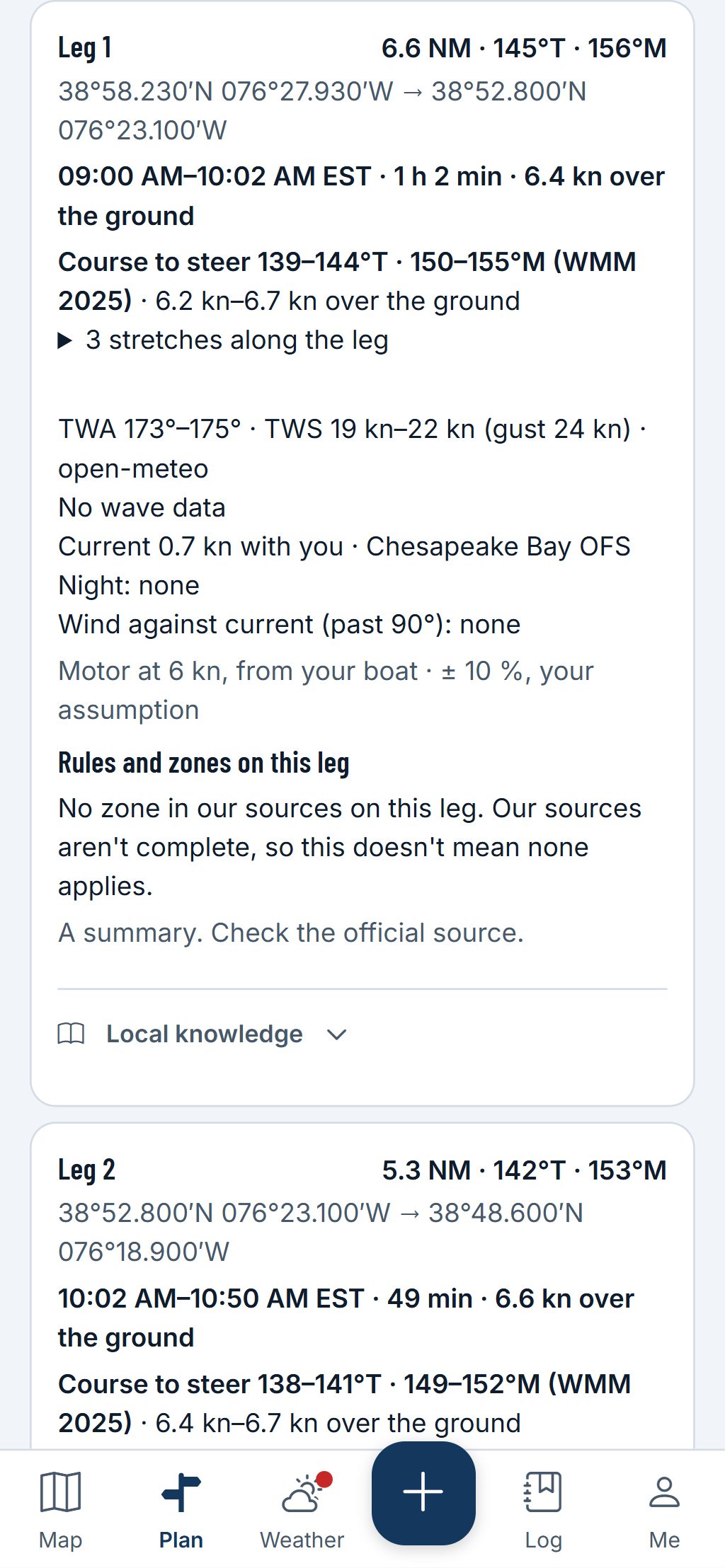
Each leg
Facts with their source, never a verdict
Tap a leg to see what it meets at your times, and where each number comes from.
- A NOAA prediction names its station; a model estimate says so and names the model.
- The limits that colour a leg are the ones you set for your boat, never ours.
- Canadian waters have no chart layer: the app says plainly which country gets what.
Planning aid, not for navigation. Carry official charts and Notices to Mariners.
All 44 map layers in HuntGrid Sailing
Depth, nautical features, weather and visibility: every layer you can turn on in HuntGrid Sailing today. A planning aid, not for navigation.
Base maps (4)
Topo · Satellite · Hybrid · Dark
Aerial and satellite imagery (5)
Sentinel-2 imagery · Yukon imagery · Québec imagery · Ontario imagery · New Brunswick imagery
Terrain (4)
Relief detail · Terrain shapes · Canopy height (modelled) · Openings & edges (modelled)
Roads, trails and access (1)
Boat launches (agencies)
Rivers and lakes (1)
Rivers and streams
Depth (4)
Depth contours (survey lines) · Depth model (shading and smooth contours) · Approximate depth between soundings · Chart-datum depth (draft shading)
Nautical (3)
Inland chart features (from USACE IENC) · Waterway miles (ICW and rivers) · Seamarks, marinas and anchorages (OpenStreetMap)
Weather and forecasts (15)
Weather stations · City forecasts · Wind flow (forecast) · Radar · Wind arrows (forecast) · Wind speed (forecast) · Gusts (forecast) · Temperature (forecast) · Cloud cover (forecast) · Lightning · Lightning from satellite · Satellite clouds · Thunderstorm outlooks and watches · Forecast visibility · Weather alerts
Fire and smoke (5)
Wildfire smoke (forecast) · Smoke (satellite analysis) · Wildfires · Fire hotspots (24 h) · Fire danger (Canada)
Snow and water levels (2)
Snow depth · Water levels
The names as the app’s layer panel shows them. Some layers cover only the places their source maps; each says where in the app.
One free account for every HuntGrid app
Already use HuntGrid Hunt, HuntGrid Fishing, HuntGrid Offroad, HuntGrid Climbing or HuntGrid Backcountry? Sign in to HuntGrid Sailing with the same account, on every device.
Questions
Still have a question? Read the HuntGrid Sailing help pages or email support@huntgrid.net.
Is HuntGrid Sailing really free?
Yes. You can start free with no credit card. HuntGrid Sailing is in open beta: anyone can use it while we keep building. There are no ads.
Is it a chart? Can I navigate with it?
No. HuntGrid Sailing is a planning aid built on public data, not an official chart and not for navigation. In US waters its map is derived from NOAA ENC® data; in Canadian waters there is no chart layer. Carry official charts and Notices to Mariners, as Canada’s Navigation Safety Regulations, 2020 require on Canadian vessels.
Where do the tides, currents and forecasts come from?
From public agencies and open models. A NOAA prediction names its station; a model estimate says so and names the model; each forecast names its model and run time. Warnings show as the agency issued them, with a link. The app never tells you a passage or a time to leave is fine: you decide, with your own limits.
Can I use my HuntGrid account?
Yes. Every HuntGrid app shares one free account: sign in to sailing.huntgrid.net with the same email and password or passkey, on every device.
Does it work on iPhone and Android?
Yes, and on tablets and computers. It’s a web app: open sailing.huntgrid.net, then on iPhone choose Share and Add to Home Screen in Safari, or on Android choose Install app in Chrome. It isn’t in the App Store or Google Play yet.
Is HuntGrid Sailing available in French?
Yes. The whole app is available in English and Canadian French, as HuntGrid Voile. Voir la page en français.
Plan your next passage on the map
Create a free account and open HuntGrid Sailing in your browser. The same account works for every HuntGrid app.
Already have an account? Sign in