 HuntGrid
Whitetail and mule deer
The deer hunting app built around your stands
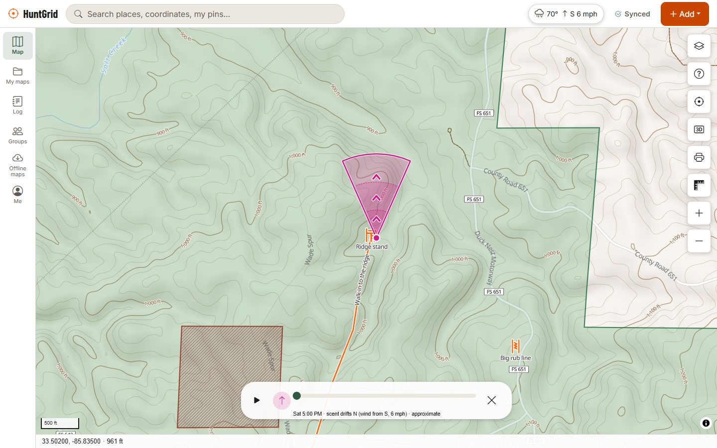
Put your stands on the map, see where your scent will drift before you climb in, and keep your trail cameras, sign and sightings in one place. HuntGrid works on your phone and your computer, and keeps working with no signal.
Map data © OpenStreetMap contributors, © OpenMapTiles; terrain: Copernicus WorldDEM-30 (credits)
How deer hunters use HuntGrid
Plan every sit around the wind
A mature deer lives by its nose. The tools below help you choose the right stand for the day and get in and out without being winded.
Stands with their good winds
Mark ladder stands, hang-ons, saddles and box blinds with their height and the winds each one hunts best on. Every stand gets a daily 1 to 5 hunt score, with the reasons.
Scent cone and thermals
Step through the forecast hour by hour to see where your scent goes, with wind arrows on the map and a thermals hint for hillsides at dawn and dusk.
Funnels, saddles and benches
Hillshade, contours, slope shading and 3D terrain show the pinch points deer travel. Mark them with funnel, terrain saddle, bench and bedding area icons.
Trail cameras that tell a story
Put each camera on the map with the way it faces, import photos from any brand, and see activity by hour, moon, temperature, wind and pressure.
Moon and solunar times
Sunrise, sunset, moon phase and solunar periods for any place, so you can compare them with the deer movement your cameras and logs record.
Public land and who to ask
Public land across the US and Crown land across most of Canada, with the source and date. Parcel lines, and in many US states the owner's name on rural land, so you know who to ask for permission.
Map data © OpenStreetMap contributors, © OpenMapTiles; terrain: Copernicus WorldDEM-30 (credits)
Scouting and the rut
Read your own sign, not just the calendar
Rut timing varies by region and every buck is different, so HuntGrid doesn't guess it for you. It helps you build your own record instead.
- Drop rubs, scrapes, beds, game trails and crossings as you find them, and draw rub lines and travel routes between them.
- Log each deer you see in three taps, with the weather recorded for you, then view a heatmap of sightings by time of day and month.
- Your season recap shows the hours you hunted, the deer you saw and the stand where you saw game most often.
- Turn on alerts for when the wind is right for a stand or the pressure drops.
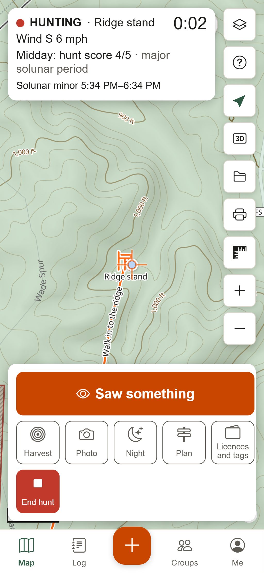
- Hunt Mode keeps the hunt clock, wind, hunt score and solunar times in view, with big buttons and no ads.
Your first deer hunt with HuntGrid
Find your ground
Turn on the land layers and tap the map to see public, Crown, private or closed land with its source and date, and the hunting unit you are in.
Scout from home
Use 3D terrain and satellite imagery to find funnels, saddles and the edges between bedding cover and food. Pin your best guesses before you walk.
Hang your stands
Add each stand with its height and good winds. Range rings at 20, 30 and 40 yards help you plan your shooting lanes.
Download the area
Save the map around your stands for offline use (three areas on the free plan), so the map, your pins and the forecast work with no bars.
Sit the right stand
Check the hunt score and scent cone the night before, pick the stand the wind favours, and plan an entry route that keeps your scent off the trails.
After the shot
Mark the hit site, log the harvest, draw the blood trail as a recovery path, and keep a photo of your tag in the licence wallet.
Seasons, bag limits, shooting hours, baiting and blaze orange rules vary by state, province and unit. The official regulations always have the final word.
Questions
Still have a question? Read the help pages or email support@huntgrid.net.
What is the best app for deer hunting?
The best one is the one that fits how you hunt. HuntGrid is built for stand hunters: stands with the winds they hunt best on, a scent cone through the forecast hours, a daily hunt score, trail cameras, sign icons, 3D terrain and public land, on one map that works offline. Every feature is in the free plan, so you can try it on your own ground before you decide.
Is there a free deer hunting app that works offline?
Yes. HuntGrid's free plan has every map layer and feature and three offline areas. Download the ground around your stands and the map, your pins and the saved forecast work with no cell signal. It installs from the browser on iPhone, Android and computers; there is no App Store or Google Play app yet.
How do I know which way my scent is blowing?
Pick a stand and HuntGrid draws a scent cone from the hourly wind forecast, with a time slider and a thermals hint for slopes. It is a guide built on a forecast: check the real wind on site with a wind checker or a puff of powder before you climb.
Can HuntGrid predict the rut?
No. Rut timing varies by region and from year to year, and we don't pretend to predict it. HuntGrid shows moon phase and solunar times, and your trail cameras and sightings show activity by hour, moon, temperature, wind and pressure, so you can learn the pattern on your own ground.
Does it show deer seasons and legal shooting hours?
HuntGrid has a season calendar and a legal-light countdown. Season dates and rules appear once a person has checked them against the official regulations, with a link to them. Seasons, bag limits and shooting hours vary by state, province and unit: the official regulations have the final word.
Can I bring my stands from onX or HuntStand?
Yes. Export a GPX or KML file from your other app or GPS unit and import it in HuntGrid: your stands, pins and tracks come with you.
Your next hunt starts on the map
Create a free account, download your area and head out. No credit card, no per-state fees.
Already have an account? Sign in