 HuntGrid
Where to hunt
Public hunting land map: “Can I hunt here?”
Tap anywhere on the map and HuntGrid tells you what kind of land you’re on (public, Crown, an access program, private or closed), the rule for hunting it in plain words where that rule has been verified, and where the answer comes from.
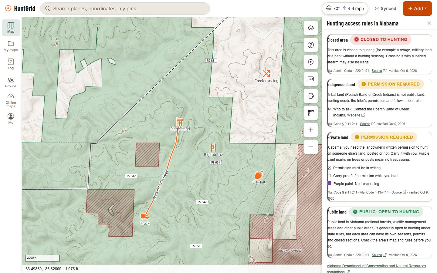
Map data © OpenStreetMap contributors, © OpenMapTiles; terrain: Copernicus WorldDEM-30 (credits)
What the land map shows
The “Can I hunt here?” layer combines many official sources into one colour per spot, and every tap shows the pieces behind it.
Public and Crown land
National forests, BLM land, state wildlife areas and other public land across all 50 states, and Crown land across most of Canada, with parks and protected areas on top.
Access programs
Many state programs that open private land to hunting, such as Montana Block Management, Wyoming Walk-In Areas, Idaho Access Yes! and Michigan HAP, each with its own rules.
Parcels and who to ask
Parcel lines, and in many US states the owner’s name on rural land when you’re signed in, so you know who to ask. Elsewhere it points you to the county assessor, and in Canada it links to the provincial land registry.
Closed land and buildings
Parks closed by law, game preserves, refuges and other closures. Where a state or province’s safety-zone distance is verified, the card warns when a mapped building is inside it.
Roads, trails and gates
Roads and trails open to vehicles from the Forest Service’s motor vehicle use maps, BLM routes and several provinces, with gates and washouts other hunters reported, checked before they show.
Boundary alert
Turn it on and, while you record a track or hunt, your phone buzzes when you get within a distance you choose of land that needs permission or is closed. It works offline too.
How it works
How “Can I hunt here?” answers
Tap the spot
Tap the map, or long-press and choose What’s here. Offline, the answer comes from the tiles you downloaded.
The strictest layer wins
Where areas overlap, the most restrictive one decides: a park over Crown land, a closure over everything, a building’s safety ring over open land.
The rule in plain words
Each state and province has an access rule for each kind of land, with the law it comes from. A person checks every rule before hunters see it; until then the card says the rules haven’t been verified yet and points you to the official regulations.
Source and date
Every answer names its sources and their dates. If something looks wrong on the ground, “Report a problem” sends it to us.
We never assume land is open
Green on HuntGrid means a source or a law says the land is open, a verified rule covers that kind of land, and nothing on top (a park, a school, a built-up area or a building’s safety ring) says otherwise. When in doubt, the answer is “unknown”, never green.
Check the unit and season too
Open land still has seasons, weapon rules and unit limits. Hunting unit maps and seasons and legal hours sit on the same map.
Signs and local by-laws
Posted signs, leases and municipal discharge by-laws aren’t all on any map. What you see on the ground counts.
Ask before you hunt private land
Owner names are there to help you ask for permission, nothing else. Landowners can ask us to hide a name at any time.
HuntGrid is a guide, not the law: the official hunting regulations of your state or province always have the final word.
Questions
Still have a question? Read the help pages or email support@huntgrid.net.
How do I know if land is public for hunting?
Start with a map of land ownership, then check the rules for that kind of land in your state or province. HuntGrid shows public and Crown land, access programs and closures on one layer; tap a spot to see its land type, the rule where it has been verified, and the official sources. Confirm with the regulations and any signs on the ground.
Is all public land open to hunting?
No. Many parks, refuges, historic sites, campuses and areas near buildings are closed or limited, and rules differ by state and province. HuntGrid marks those areas and answers “unknown” rather than “open” when it can’t be sure.
Can I see who owns private land?
In many US states, yes: signed in, tap a rural parcel to see the owner’s name, acreage and parcel number from free public records, to ask for permission. In other states the card points you to the county assessor, and in Canada to the provincial land registry.
Can I hunt on Crown land in Canada?
Often, with the right licence, but not everywhere: parks, reserves, leases, closures and local rules change it from place to place. HuntGrid shows Crown land across most of Canada with parks and closed areas on top. The provincial regulations have the final word.
Does the land map work offline?
Yes. Include the “Can I hunt here?” layer in an offline area (the parks layer comes with it) and tapping the map answers from the downloaded tiles. The boundary alert works offline as well.
Where does the land data come from?
From government sources and open public data, such as the USGS Protected Areas Database, Canada’s protected areas database, provincial open data and state parcel layers. Each answer names its source and date.
Your next hunt starts on the map
Create a free account, download your area and head out. No credit card, no per-state fees.
Already have an account? Sign in