 HuntGrid
Every map layer, in every app
127 map layers across the HuntGrid apps, from lidar terrain and public land to lake depth, tides and wildfire smoke. Hunting units alone come from more than 370 agency datasets in 61 states, provinces and territories.
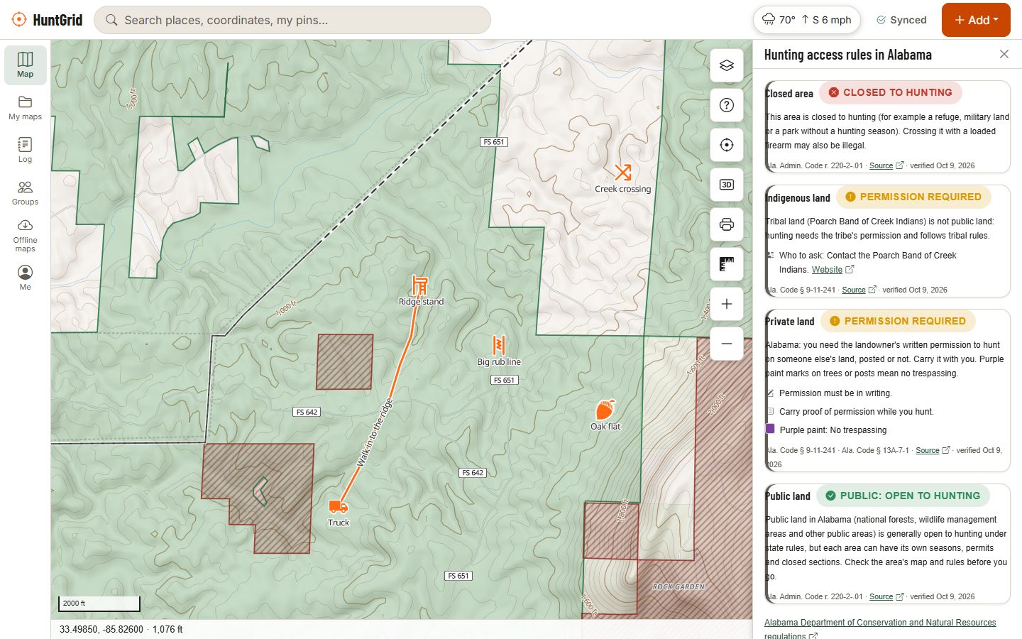
Map data © OpenStreetMap contributors, © OpenMapTiles; terrain: Copernicus WorldDEM-30 (credits)
Layers in each app
Each app shows the layers that help with what it does. Many are shared: the basemaps, radar and relief detail are in all of them, and public land and the lidar terrain in all but Sailing, whose chart keeps the land plain.
- 63Hunt
- 72Fishing
- 58Offroad
- 64Backcountry
- 52Climbing
- 30Sailing
- 56Rockhounding
Basemaps and imagery
The map under everything. Pick one; the overlays sit on top.
- TopoWorldwide
- Hunt
- Fishing
- Offroad
- Backcountry
- Climbing
- Sailing
- Rockhounding
- SatelliteUS and Canada
- Hunt
- Fishing
- Offroad
- Backcountry
- Climbing
- Sailing
- Rockhounding
- Hybrid (satellite with roads and names)US and Canada
- Hunt
- Fishing
- Offroad
- Backcountry
- Climbing
- Sailing
- Rockhounding
- DarkWorldwide
- Hunt
- Fishing
- Offroad
- Backcountry
- Climbing
- Sailing
- Rockhounding
- Ontario imageryOntario
- Hunt
- Fishing
- Offroad
- Backcountry
- Climbing
- Sailing
- Rockhounding
- New Brunswick imageryNew Brunswick
- Hunt
- Fishing
- Offroad
- Backcountry
- Climbing
- Sailing
- Rockhounding
- Québec imagerySouthern Québec
- Hunt
- Fishing
- Offroad
- Backcountry
- Climbing
- Sailing
- Rockhounding
- Fishing topo, dark and bright-sun stylesWorldwide
- Fishing
- Nautical chart from NOAA ENC (day, dusk and night)US
- Sailing
Terrain and lidar
Shading, contour lines and slope from 30 m world terrain, and from lidar where the US and Canada have it, with views computed from it.
- Lidar terrain detailUS and Canada
- Hunt
- Fishing
- Offroad
- Backcountry
- Climbing
- Rockhounding
- Terrain (elevation)Worldwide
- Hunt
- Fishing
- Offroad
- Backcountry
- Climbing
- Rockhounding
- HillshadeWorldwide
- Hunt
- Fishing
- Offroad
- Backcountry
- Climbing
- Rockhounding
- Contour linesWorldwide
- Hunt
- Fishing
- Offroad
- Backcountry
- Climbing
- Rockhounding
- Slope angleWorldwide
- Hunt
- Fishing
- Offroad
- Backcountry
- Climbing
- Rockhounding
- 3D terrainWorldwide
- Hunt
- Fishing
- Offroad
- Backcountry
- Climbing
- Rockhounding
- Relief detailWorldwide
- Hunt
- Fishing
- Offroad
- Backcountry
- Climbing
- Sailing
- Rockhounding
- Terrain shapesWorldwide
- Hunt
- Fishing
- Offroad
- Backcountry
- Climbing
- Sailing
- Rockhounding
- Canopy height (modelled)US and Canada
- Hunt
- Fishing
- Offroad
- Backcountry
- Climbing
- Rockhounding
- Openings & edges (modelled)US and Canada
- Hunt
- Fishing
- Offroad
- Backcountry
- Climbing
- Rockhounding
- Steep rock (60° and steeper)Worldwide
- Climbing
- Mapped landslides (USGS)US
- Climbing
- Rockhounding
Land, access and hunting
Who manages the land, what the rules say, and where the hunting units are, each with its source.
- Can I hunt here?US and Canada
- Hunt
- Parks, schools and built-up areasUS and Canada
- Hunt
- Public land (US)US
- Hunt
- Fishing
- Offroad
- Backcountry
- Climbing
- Rockhounding
- Public land (Canada)Canada
- Hunt
- Fishing
- Offroad
- Backcountry
- Climbing
- Rockhounding
- Protected areas (worldwide)Worldwide
- Hunt
- Fishing
- Offroad
- Backcountry
- Climbing
- Rockhounding
- Hunting units and zonesUS and Canada
- Hunt
- Access programsUS and Canada
- Hunt
- Public access easementsUS
- Hunt
- Parcel outlines (US)US states with free parcel data
- Hunt
- Parcel outlines (BC, NB, Yukon)Canada
- Hunt
- Wildlife: flyways and seasonal rangesUS and Canada
- Hunt
- Legal land grid (Prairies)Alberta, Saskatchewan, Manitoba, BC Peace
- Hunt
- Fishing
- PLSS grid (townships and sections)US
- Hunt
- Offroad
- Backcountry
- Rockhounding
- Mining claims (BLM MLRS)US
- Hunt
- Offroad
- Backcountry
- Rockhounding
- Counties and districtsUS and Canada
- Hunt
- Fishing
- Offroad
- Official place names (Canada)Canada
- Hunt
- Fishing
- Offroad
Rocks, minerals and fossils
What the land manager says about collecting, where minerals and fossils are recorded, and old mine workings to keep clear of.
- Can I collect here?US and Canada
- Rockhounding
- Collecting sitesUS and Canada
- Offroad
- Backcountry
- Rockhounding
- Mineral occurrencesUS and Canada
- Rockhounding
- Fossil-bearing formationsUS and Canada
- Rockhounding
- Stream-sediment geochemistry (USGS NURE)US
- Rockhounding
- Closure ordersUS and Canada
- Rockhounding
- Old mine workingsUS and Canada
- Hunt
- Offroad
- Backcountry
- Climbing
- Rockhounding
- Rock shops and museumsUS and Canada
- Rockhounding
Trails, roads, camps and crags
Official trails and vehicle routes first, OpenStreetMap beside them and labelled as unofficial.
- Roads & trails open to vehiclesUS and Canada
- Hunt
- Fishing
- Offroad
- Rockhounding
- Official trails & portagesUS and Canada
- Hunt
- Fishing
- Offroad
- Backcountry
- Climbing
- Rockhounding
- Trails, tracks and gatesWorldwide
- Hunt
- Fishing
- Offroad
- Backcountry
- Climbing
- Fuel, camps & trailheads (OpenStreetMap)US and Canada
- Hunt
- Fishing
- Offroad
- Backcountry
- Rockhounding
- Campgrounds (official)US and Canada
- Hunt
- Fishing
- Offroad
- Backcountry
- Climbing
- Rockhounding
- Registered tourist campgrounds (Quebec)Québec
- Hunt
- Fishing
- Offroad
- Backcountry
- Backcountry campsites, water & access (official)US and Canada
- Hunt
- Fishing
- Offroad
- Backcountry
- Climbing
- Rockhounding
- Portages, canoe routes & rapids (OpenStreetMap)US and Canada
- Hunt
- Fishing
- Backcountry
- Climbing
- Official staging areasUS and Canada
- Offroad
- Trail reports from ridersUS and Canada
- Offroad
- How complete is this area?US and Canada
- Offroad
- Road weather (passes)US
- Offroad
- Data coverage: campsitesUS and Canada
- Backcountry
- Data coverage: portagesUS and Canada
- Backcountry
- Reports from trippersUS and Canada
- Backcountry
- Crags, routes & boulders (OpenStreetMap)US and Canada
- Backcountry
- Climbing
- Climbing closuresUS and Canada
- Backcountry
- Climbing
- Climbing gymsUS and Canada
- Climbing
Water, depth and fishing
Lakes and rivers, lake depth from agency surveys, structure, access and the rules on the water.
- Rivers and streamsUS and Canada
- Hunt
- Fishing
- Offroad
- Backcountry
- Climbing
- Lakes and riversUS and Canada
- Fishing
- Backcountry
- Depth model (shading and smooth contours)US
- Fishing
- Sailing
- Depth contours (survey lines)US and Canada
- Fishing
- Approximate depth between soundingsCanada
- Fishing
- Sailing
- Drop-offs (steep bottom)US
- Fishing
- Structure Scout (humps, saddles, points, turns, flats, channels)US
- Fishing
- Depth band and shallow-water warningUS and Canada
- Fishing
- Trout stream classesUS
- Fishing
- Regulation zonesUS and Canada
- Fishing
- Special-regulation watersUS and Canada
- Fishing
- Fishing accessUS
- Fishing
- Backcountry
- Sailing
- Rockhounding
- Fishing access (share-alike agency data)US
- Fishing
- Backcountry
- Fishing access from OpenStreetMapWorldwide
- Fishing
- Backcountry
- Reach from shore (deep water within a cast of public shore)US
- Fishing
- River hazardsUS
- Fishing
- Backcountry
- Weirs and dams from OpenStreetMapWorldwide
- Fishing
- Backcountry
- River gaugesUS and Canada
- Fishing
- Fish stockingWhere agencies publish it
- Fishing
- Ice roadsWhere agencies publish it
- Fishing
Coast and big water
Tides, currents, buoys, charts and the sea’s surface, for coastal fishing, the Great Lakes and sailing. Not for navigation.
- Tide stationsUS and Canada
- Fishing
- Tidal currentsUS
- Fishing
- BuoysNorth America
- Fishing
- Marine alerts (NWS)US
- Fishing
- Sea surface temperature and temperature breaksOceans
- Fishing
- Sea temperatureOceans
- Sailing
- Chlorophyll and colour breaksOceans
- Fishing
- Sea wavesOceans
- Fishing
- Wind on the waterOceans
- Fishing
- Wind and waves (forecast)Oceans
- Sailing
- Ocean currentsOceans
- Fishing
- Water qualityWhere agencies publish it
- Sailing
- Ice chartsUS and Canada
- Sailing
- Chart-datum depth (draft shading)Canada
- Sailing
- Seamarks, marinas and anchorages (OpenStreetMap)US and Canada
- Fishing
- Backcountry
- Sailing
- OpenStreetMap fairwaysUS and Canada
- Sailing
- Shipping lanes and traffic schemesUS and Canada
- Sailing
- Harbours, marinas, anchorages and launchesUS and Canada
- Sailing
- Rules and protected areas on the waterUS and Canada
- Sailing
- Inland chart features (from USACE IENC)US
- Fishing
- Sailing
- Waterway miles (ICW and rivers)US
- Fishing
- Sailing
Weather, fire and snow
From government weather services, shown as they issue it.
- RadarNorth America and Europe
- Hunt
- Fishing
- Offroad
- Backcountry
- Climbing
- Sailing
- Rockhounding
- LightningNorth America
- Hunt
- Fishing
- Offroad
- Backcountry
- Climbing
- Rockhounding
- Lightning from satelliteNorth America
- Sailing
- Satellite cloudsNorth America
- Sailing
- Thunderstorm outlooks and watchesUS
- Hunt
- Fishing
- Offroad
- Backcountry
- Climbing
- Sailing
- Rockhounding
- Forecast visibilityNorth America
- Sailing
- Weather alertsUS and Canada
- Hunt
- Offroad
- Backcountry
- Climbing
- Rockhounding
- Weather stationsUS and Canada
- Hunt
- Offroad
- Backcountry
- Climbing
- Rockhounding
- City forecastsUS and Canada
- Hunt
- Offroad
- Backcountry
- Climbing
- Rockhounding
- Wind flow (forecast)North America
- Hunt
- Offroad
- Backcountry
- Climbing
- Rockhounding
- Wind arrows (forecast)North America
- Hunt
- Offroad
- Backcountry
- Climbing
- Rockhounding
- Wind speed (forecast)North America
- Hunt
- Offroad
- Backcountry
- Climbing
- Rockhounding
- Gusts (forecast)North America
- Hunt
- Offroad
- Backcountry
- Climbing
- Rockhounding
- Temperature (forecast)North America
- Hunt
- Offroad
- Backcountry
- Climbing
- Rockhounding
- Cloud cover (forecast)North America
- Hunt
- Offroad
- Backcountry
- Climbing
- Rockhounding
- WildfiresUS and Canada
- Hunt
- Fishing
- Offroad
- Backcountry
- Climbing
- Rockhounding
- Fire hotspots (24 h)North America
- Hunt
- Fishing
- Offroad
- Backcountry
- Climbing
- Rockhounding
- Fire danger (Canada)Canada
- Hunt
- Fishing
- Offroad
- Backcountry
- Climbing
- Rockhounding
- Smoke (satellite analysis)North America
- Hunt
- Fishing
- Offroad
- Backcountry
- Climbing
- Rockhounding
- Wildfire smoke (forecast)North America
- Hunt
- Offroad
- Backcountry
- Climbing
- Rockhounding
- Snow depthUS and Canada
- Hunt
- Offroad
- Backcountry
- Climbing
- Rockhounding
- Water levelsUS and Canada
- Hunt
- Offroad
- Backcountry
- Climbing
- Rockhounding
- WebcamsUS and Canada
- Hunt
- Fishing
- Offroad
- Backcountry
- Climbing
Lidar under the map
On land, the terrain under the layers comes from lidar where the US and Canada have flown it: sharper shading, contour lines that fit, slope, relief detail and terrain shapes from the same detail.
Questions
Still have a question? Read the help pages or email support@huntgrid.net.
Do I pay for some layers?
No. Every layer on this page is on the free plan. No layer is locked behind a paid plan.
Do the layers work offline?
The map layers you download with an offline area come with you, including lidar where there is some. Live layers such as radar, lightning, alerts and forecasts need a connection.
Where does the data come from?
From government agencies and open data: USGS, NOAA, Natural Resources Canada, state and provincial agencies, OpenStreetMap and others. Every layer’s source and licence is in the app’s Data sources & licences page.
Why don’t I see a layer in my app?
Each app shows the layers that help with what it does: the badges beside each layer name the apps that have it. Some are always on in their app, with no switch.
Your next hunt starts on the map
Create a free account, download your area and head out. No credit card, no per-state fees.
Already have an account? Sign in